Module @stevenpg/cesium-s2
@stevenpg/cesium-s2



S2 geometry cell helpers for CesiumJS. Cover the current view with cells, render thousands of them as one batched primitive, and traverse the grid — without touching an S2 library yourself.
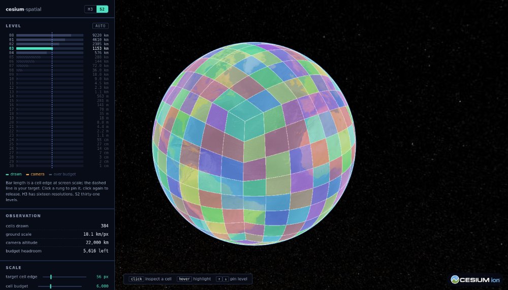
A layer that follows the camera
import { Viewer } from 'cesium';
import { S2ViewLayer } from '@stevenpg/cesium-s2';
const viewer = new Viewer('cesiumContainer');
const layer = new S2ViewLayer(viewer.scene, {
maxCells: 8000, // budget; coarsens rather than overrunning
targetEdgePixels: 72, // how big a cell should look on screen
outlines: true,
onUpdate: ({ cells, level }) => console.log(cells.length, 'at level', level),
});
Or drive it yourself
import { cellAt, neighbors, parent, S2CellLayer } from '@stevenpg/cesium-s2';
import { Color } from 'cesium';
const origin = cellAt(-122.4194, 37.7749, 13); // longitude first, Cesium-style
const patch = [origin, ...neighbors(origin)]; // always exactly four neighbors
const layer = new S2CellLayer(viewer.scene, {
style: (cell) => ({ color: cell === origin ? Color.ORANGE : Color.CYAN.withAlpha(0.3) }),
});
layer.setCells(patch);
layer.setCellStyle(parent(origin), { color: Color.MAGENTA }); // no rebuild
Cells are tokens
S2 cell ids are 64-bit integers. This library addresses cells by their canonical token — the
standard lossless hex string, like 8085809c — because tokens compare, sort into maps and survive
JSON without bigint caveats. A raw bigint is accepted anywhere a token is, and toCellId /
toToken convert between them.
How this differs from the H3 package
Not a reskin. Three things behave differently because S2 does.
No antimeridian splitting. S2's longitude interval represents wrapping natively, so a Cesium
rectangle with west > east becomes an inverted interval and covers the short way round on its
own. Rectangles wider than 180° are fine too. The H3 package has to segment extents before its
library sees them; this one does not.
The budget is load-bearing, not an optimization. S2's coverer treats a minimum level as
non-negotiable and will return millions of cells rather than truncate to maxCells. So
coverRectangle estimates from area before generating anything and steps to a coarser level.
Call cellsInRectangle directly only when you already know the extent is small.
Uniform and adaptive covers are both available. cellsInRectangle and coverRectangle give
one level everywhere, matching the H3 mental model. adaptiveCover exposes S2's native
mixed-level covering — coarse cells inside, fine cells along the edges, to hit a cell count. That
has no H3 equivalent and is what S2 is genuinely good at.
Neighbor queries are also simpler: every S2 cell has exactly four edge neighbors, everywhere, including at the poles and across cube-face seams. There is no pentagon case.
Geometry notes
Edges are geodesics. A level 0 cell edge spans a quarter turn, so boundaries densify above
200 km by default (DEFAULT_MAX_EDGE_METERS). That threshold is a no-op from level 8 down. It
matters most for outlines, which are drawn as straight segments between vertices; Cesium's polygon
fill follows geodesics regardless.
Bounds come from S2, not from the corners. cellToRectangle uses S2's own rectBound, which
accounts for edges bulging past their endpoints. A level 0 face reaches 45° of latitude while its
corners sit at 35.26° — taking the extent of four corners would understate it by ten degrees.
Poles. containsPoleInterior flags the two polar cube faces at level 0, which enclose a pole
rather than touching it, so their four corners circle the globe. This is informational: Cesium
renders those polygons correctly, and it is verified in the demo. From level 1 down a pole is
always a shared corner of four cells. Reach for the predicate if you do your own projection or
bounding-box maths, where a ring that circles the globe needs care.
API
Cells
cellAt(longitude, latitude, level), cellAtCartographic, isValid, levelOf, faceOf,
cellAreaMeters, toCellId, toToken.
neighbors (four, always), vertexNeighbors, allNeighbors, contains, intersects.
parent, ancestors, children, childrenAtLevel, compact, uncompact.
Geometry
cellToRing, cellToCellBoundary, cellsToBoundaries, cellToPositions, cellToCartographic,
cellToCartesian, cellToLngLat, cellToRectangle, cellsToRectangle, containsPoleInterior.
getCellBoundary / getCellBoundaries memoize behind a bounded cache and are safe to call every
frame. clearBoundaryCache empties it.
Cover
cellsInRectangle, coverRectangle, adaptiveCover, estimateCellCount, cellsInView,
toS2Rect.
Levels
S2_LEVELS (0 through 30), levelForMetersPerPixel, createLevelSelector (adds hysteresis),
levelEdgeMeters, levelAreaMeters, clampLevel.
Edge length is taken as the square root of average cell area rather than from S2's average-edge
metric, which s2js does not export. The two agree to within one percent, and this way the figure
comes from the library rather than a copied constant.
Cesium compatibility
Cesium is a peer dependency (>= 1.95), so this never bundles a second copy of the engine.
@cesium/engine is supported as an optional peer.
s2js is a regular dependency — a TypeScript port of Go's
S2 that runs in the browser, unlike the native-binding alternatives.
Apache-2.0.
Functions
- adaptiveCover
- allNeighbors
- ancestors
- cellAreaMeters
- cellAt
- cellAtCartographic
- cellsInRectangle
- cellsInView
- cellsToBoundaries
- cellsToRectangle
- cellToCartesian
- cellToCartographic
- cellToCellBoundary
- cellToLngLat
- cellToPositions
- cellToRectangle
- cellToRing
- children
- childrenAtLevel
- clampLevel
- clearBoundaryCache
- compact
- computeViewInfo
- contains
- containsPoleInterior
- coverRectangle
- createLevelSelector
- estimateCellCount
- faceOf
- getCellBoundaries
- getCellBoundary
- intersects
- isValid
- levelAreaMeters
- levelEdgeMeters
- levelForMetersPerPixel
- levelOf
- neighbors
- parent
- toCellId
- toS2Rect
- toToken
- uncompact
- vertexNeighbors